
Idyma Way Maps & Routes
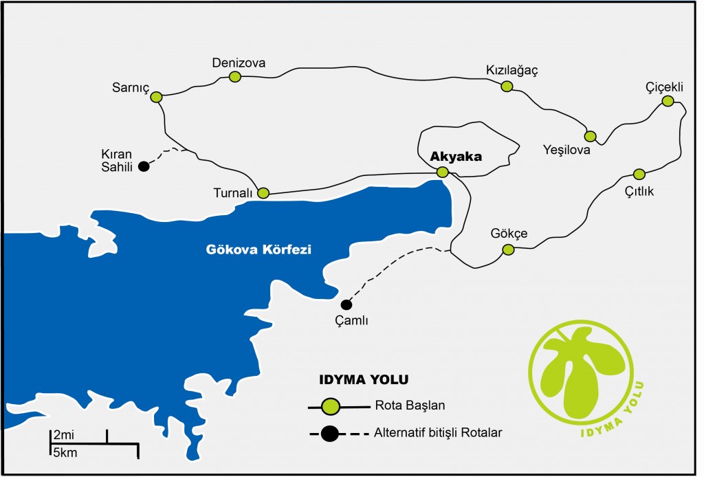
1- Akyaka –Turnalı: 18 km long route goes up to 350 meters and passes through small villages, pine forest and olive farms.
2- Turnalı–Sarnıç: 15 km long way has two alternative finishes.The Seher way ( Sunset way) is a old path going up till 800 meters with a incredible view to the Gökova Bay. An 300 years old path called Merdivenli yol (the stepped way) connects with the Carian Trail at Kıransahili.
3- Sarnıç- Denizova: the 8 km long route enters the Gerit Canyon, a nearly unknown Canyon, which is surrounded by pine forests with large caves.The route finishes at the village of Denizova.
4- Denizova- Kızılağaç : the 20 km long route passes the Menteşe Hills with average altitude of 600 meters. Many highlights such as the Damla Canyon and Carian tombs.
5- Kızılağaç – Yeşilova: 7 km long route passes through the dramatic Ula Canyon. The walls which reaches 400 meters, enclosing an endemic flora. Even in the hottest summer this canyon is walkable; it was once the main stream of the river İdymos, the ancient river on which the city of Idyma was founded.
6- Yeşilova- Çiçekli: The 15 km long route passes through a wild area which is known as the biggest Carian openair museum. Many small paths and ancient roads shows us that these paths connected the Carian Sites.
7- Çiçekli- Çıtlık: The 20 km long route begins at the nearly 100 years old Italian way which the İtalians build up during the Invasion after World War 1. The path takes us through Portakallık to the Kybele Temple build up about 2000 BC.
8- Çıtlık- Gökce: The 15 km long path passes through the small villages Sirinköy and Akçapınar to Gökçe where it is also connected to the Carian Trail.
9- Gökçe- Akyaka: 10 km up through the main canyon of Gökçe, the path follows many olive farms and reaches the beach at Gemi Koyu (Boat Bay). The route follows through farms and finally reaches Kite Beach at Akyaka.
10 – Akyaka – Sakar- Idyma –Akyaka: The 20 km long route is a inner circle for its own. The route starts at Akyaka and goes up to the highest hill to the Sakar Summit (990 meters). The route goes then down through the ancient site of Idyma and Gökova village and turns back to Akyaka.