

My interest in trekking started in 2006 on the Lycian Way and has increased over time to the point where it is a virus in my mind. For over a year, a virus has now literally spread to every area of our lives. My desire to be in nature, like the virus, is not easily ignored. We spent the spring months of 2020 locked in our houses. A year later, as if confirming the saying “history repeats itself”, we were again locked down.
The virus inside me was bothering me – for two years, I had spent the spring months, which is the most ideal season for trekking, without any hiking. The opportunity to immerse myself in nature and stretch my feet again came with the Tolerance Trail, which was opened for walking in 2017.
Until I found the Tolerance Trail, which is both close to Istanbul and relatively short (total length 77 km), I didn’t know of a trail which which could be walked without breaking curfews. That’s why I decided to set out at the beginning of April 2021.
The Path of Tolerance was named after the Edict of Tolerance. The Edict of Tolerance, which officially ended Diocletian’s persecution of Christianity and was named after the Roman Emperor Galerius, was issued by the Roman quartet (tetrarchy) consisting of Galerius, Licinius, Constantine and Maximinus Daza. It was proclaimed in 311 in Nicomedia (modern-day Izmit), which was the capital of the Roman Empire at that time. This proclamation removed all previous restrictions on the Christian religion, allowing it and all other religions to be practiced in the Roman Empire.
At the end of the edict are the words, “This edict was issued on the day before the first day of May.” In other words, the edict was published on April 30. Therefore, walking the Path of Tolerance in April means walking in the month when the edict was announced. In addition, the month of Ramadan, which is described as the month of tolerance according to Islam, started in this month in 2021. I set out on April 6, both before the start of Ramadan and avoiding the curfew.
If you divide the total 77 km route into approximately lengths of 20 km on a daily basis, you can walk the entire route in 3.5-4 days. When I set out on Tuesday, I planned to finish the march on Friday at the latest and return home before the weekend curfew started.
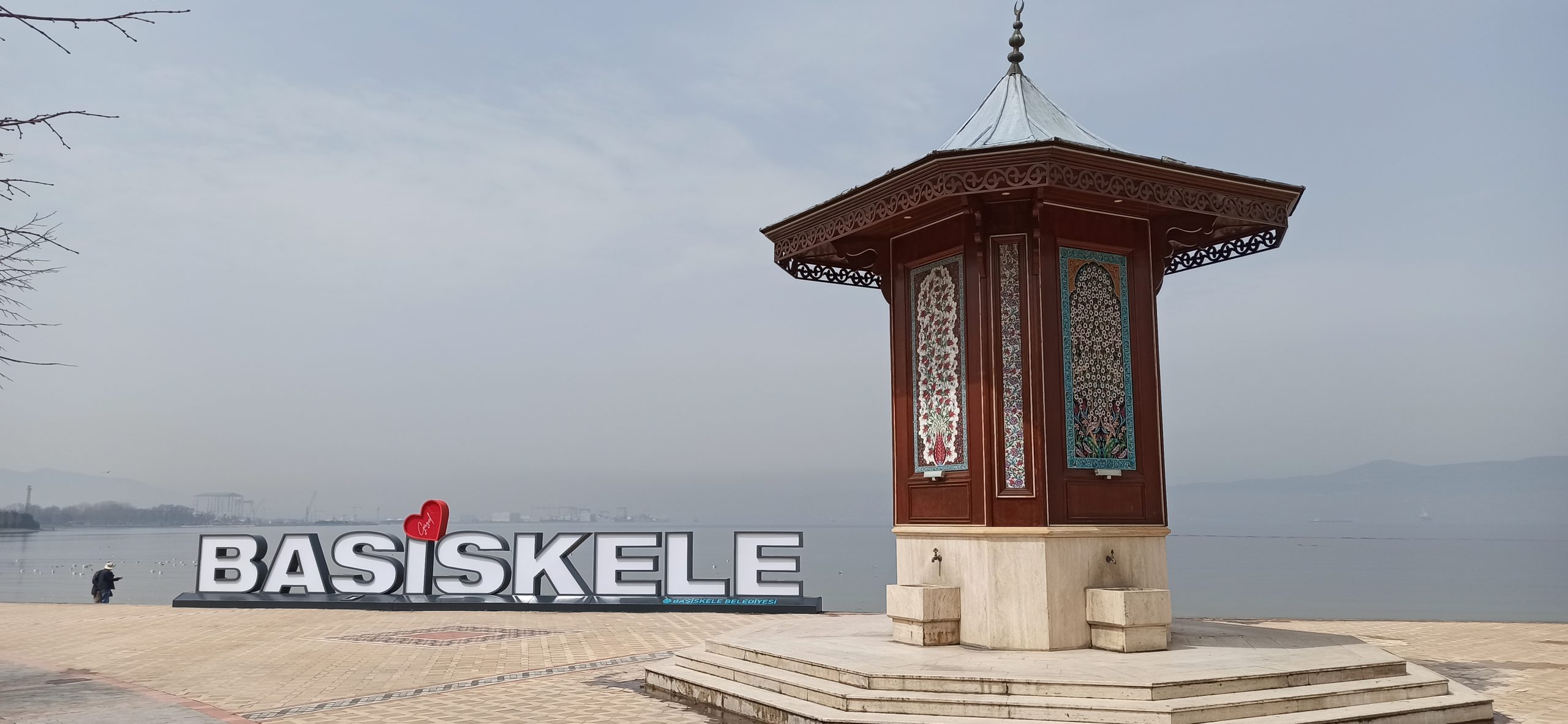
İzmit Gulf at Başiskele
The route, which starts from Izmit, follows a fairly straight route, wandering the Gulf of Izmit along the coast, and arrives at Basiskele. If the weather is favorable, you can reach Başiskele without much effort. Unfortunately, as you walk along the coast of Izmit Bay, you start to feel the negative effects of heavy industry and unplanned urbanization with the smell in the air. The unique rotten egg smell of hydrogen sulphide gas is unfortunately only a small consequence of the ecological destruction that humanity has caused to the environment. Fortunately, when you turn from the sea coast to the mountains, you forget about the damage that humans have done to nature for a while and focus on your new target, namely the Samanlı Mountains…
The climb, which starts from Başiskele, takes you gradually to the foothills of the Samanlı Mountains. As you ascend, the view of the Gulf of Izmit appears behind you. The old American College in Bahçecik – then Bitinya High School – can be a good stop before starting a steeper climb. When you set off again from the high school, you follow a dirt forest road. After that, you continue to climb on the paths in the forest towards Servetiye Karşı Village, sometimes straight and sometimes in a zigzag.
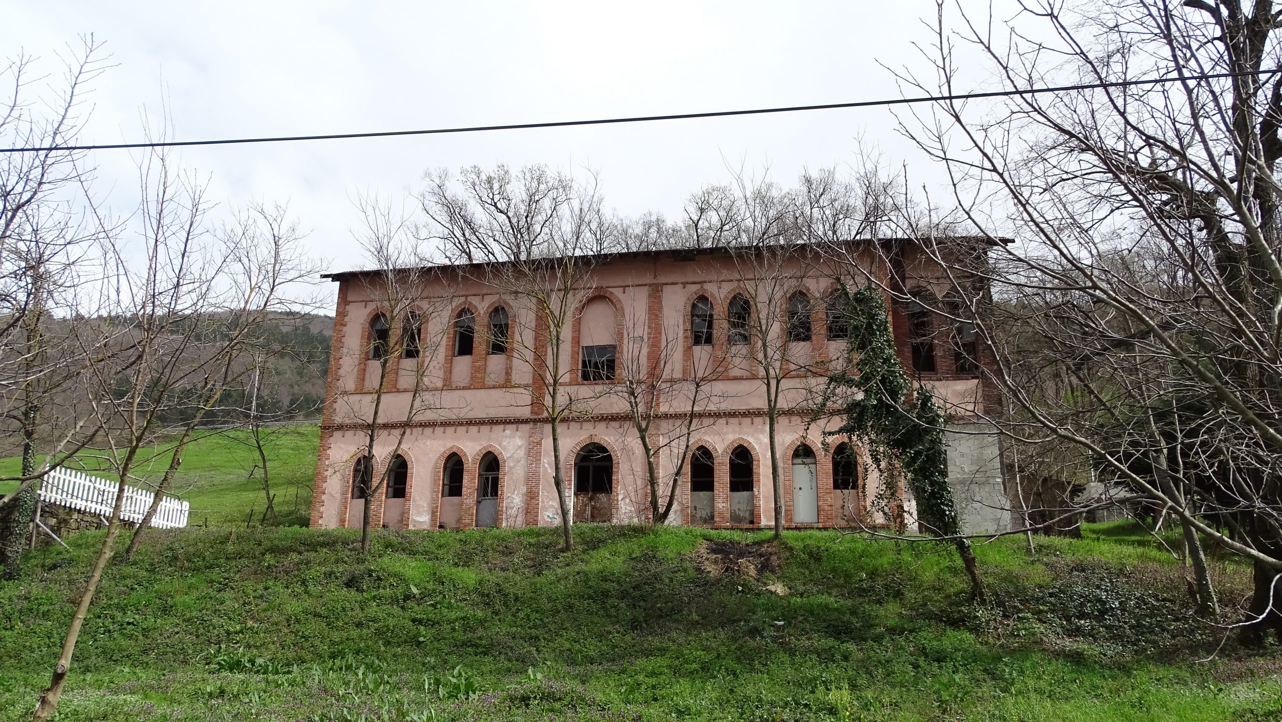
Bitinya High School, now abandoned
Just before you come to Servetiye Karşı Village, you come across the Bahçecik Trenches from the War of Independence. You can camp in this area, which is also a recreation area, but there is no water here. 3km after the trenches, you arrive at the Servetiye Karşı Village and complete the first day. The next day, remember to admire the view of the Gulf of Izmit from the village.
I camped the first night in an unfinished construction site. Right next to the construction, there was the Huzur Tepesi Fountain and an unfinished toilet opposite it. So for the moment, it was an ideal place for me as a campground. However, when the constrution is complete, it may be possible to find a flat camping place around the fountain.
On the second day I set out, planning to arrive at Kırıntı Village in the evening. At this point, you leave the view of the bay behind you. Now you look over the big and small villages of the Samanlı Mountains and the Beşkayalar Nature Park. The road continues downwards until Kirazdere Stream. Just after Servetiye Karşı Village, the newly restored Servetiye Taş Mosque can be your first stopover. The mosque is closed except for certain days and times, but there are picnic tables in the courtyard. The view is also quite impressive. When I was there, unfortunately, the water in the modern toilet was not running. As I learned later, the pipes had burst due to the frost in winter, so they cut off the water. After the mosque, you descend a very pleasant dirt road to a bridge over the Kirazdere Stream, adjoining a recreation area called Kenan’s Place.
When I arrived at Kenan’s place, Kenan Bey, who gave his name to the place, was also there. When he invited me to have tea, I decided to take a short break. Later, a person from the village joined us. Knowing the pandemic rules, at first we paid attention to our physical distance. Kenan Bey, learning that I was trying to go to Kırıntı Village via Menekşe Plateau, tried to discourage me. The villager also confirmed what Kenan Bey told. They said that there would most likely be snow on the road and that walking in the snow will make you very tired. A storm was expected in the evening and rainy and snowy weather was expected the next day. Apparently, it was difficult to go through those sections without walking in the snow. They said that many people were lost in these parts of the road, that they were in danger of freezing, that they were rescued by the gendarmerie, that there were wild animals such as bears, wolves and jackals in the forest, and how difficult it would be to stay in a snowy forest at night.
Honestly, hearing all this negative information from someone who said he knew the area like the back of his hand worried me. While I thought there was some truth in what they said, I couldn’t help but wonder if they were exaggerating a little to discourage me. I was undecided; I had a few days to finish my walk by the end of the week. Indeed, it was predicted that the weather would deteriorate for Thursday and the temperature would drop considerably. Anyway, in case of this bad weather, I wanted to pass the difficult mountain stage and reach Kırıntı Village as soon as possible. If I wanted to return to Istanbul on Friday, I had to somehow reach Kırıntı Village at the end of that day.
In the end, I decided to take my chances, risking everything. At worst, I could go back. I was quite surprised when saying goodbye to Kenan Bey, he replied that we would meet again. He was very sure that I would not be able to continue on the road due to the snow and return. He bid me farewell by saying, “You go, but stay here when you return.”
After setting off from Kenan’s Place, the route gradually rises, ascending from 230 meters to 910 meters and then descending to 825 meters; then it goes up to 943 meters again. Before then, there is a water point facility called Veysel Uncle’s Place (Soğukpınar water source) at around 690 meters. When I arrived at the facility, the employees were having a meal by the fire. I told them what Kenan Bey had told me and asked about the snow situation on the road. They said that there might be snow at altitude, but they didn’t think it was too bad to pass. This information gave me some relief and after a short break, I set off again without wasting time.
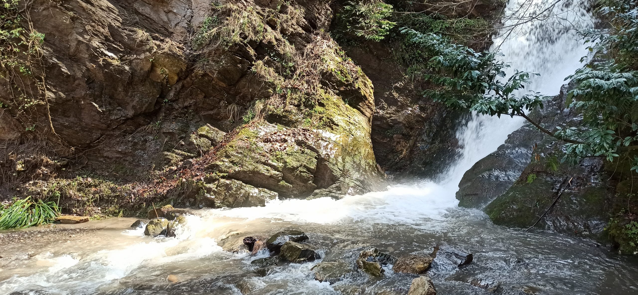
When I started again on the path, I encountered snow clusters. The snow that accumulated on the right and left of the path through the forest increased enough to block the whole road as I continued. Earlier, I encountered snow at an altitude of 1850 meters on the Lycian Way in an April and traveled through the snow for a certain period of time. However, this time the distance covered with snow was much longer and the snow thickness was about 30 cm.

The snow gets deeper
With the help of my walking poles, I continued walking through the snow. Indeed, trying to move forward in the snow with a loaded bag was tiring. Fortunately, at the end of a 2 km snow walk, the forest road gradually opened up and the snow began to fall behind. Thus, I had a little snow walking experience and completed the most difficult part of the route. Or so I thought.
There is a flat area called Kurudere Yaylası – Dry-Valley Meadow – at an altitude of 850 meters, after the 910-meter summit. In the guidebook of the Path of Tolerance, it was written that the stream here could be crossed by stepping on the stones on the stream. How hard could it be to cross a stream in a place called “Kurudere”? But this part was more difficult than the snow pass. The creek was swollen by melting snow waters, and had almost turned into a river. The stepping-stones were submerged under water. Relying on my poles and waterproof shoes, I decided to walk over the stones in the stream, using stepping stones that I could not see. As soon as I took my first step, I realized that I had made the wrong decision, but it was too late to turn back. The slightest wrong move would cause me to lose my balance and fall into the water. That’s why I continued on my way with very balanced but slow steps. I had crossed safely, but my shoes were completely submerged. I continued my walk in shoes with water gushing from all sides.
Kurudere was teasing me. In order to continue, I had to pass through three more crossings on the stream, all running just as fast. My shoes didn’t even have a chance to dry anymore. There was only one good thing about this icy wetness, and that was that the cold water gave my tired feet a rest.
After the Dry-Valley Meadow crossing, the route ascends close to the Menekse (Violet) Plateau, but it does not exactly pass through it. If you want to see or camp at the Menekşe Plateau, you should leave the Tolerance Way route.
Afterwards, the route passes through a beech forest and arrives at the Beech Forest Farm. The farm and its surroundings are ideal for camping, with a fountain in front of the farm. If you are lucky, you can meet with the people at the farm and stay at the farm. Since there was no one there when I arrived and there was a constant barking guard dog on the farm, I continued on my way to Kırıntı Village. When you arrive at Kırıntı Village, about 2 km after the farm, you can finish your day’s walk.
When I arrived at Kırıntı Village, there was no one around; it was almost like a ghost village. The stove was burning in the village cafe, but there was no one inside. It was as if an unbelievable event had happened, and all the villagers had vanished. I saw a two-storey house with a car parked in front of the village cafe. I knocked on the door, thinking maybe there was someone at home; a villager opened the door. I told him that I wanted to talk to the headman or imam to find a sheltered place where I could pitch a tent, close to the fountain. Fortunately, this person turned out to be the imam of the village; luck was again with me.
The imam said I could stay in the empty flat under his house. Thus, my accommodation problem was solved by being promoted from a tent to what I considered as a five-star hotel under those conditions.
The place I was kindly offered served as a guest house and health center. The flat, which also had electricity, had sofa beds, blankets, chairs, a table and a stove. I didn’t have to set up a tent or use my sleeping bag. The imam even lit the stove for me. It never occurred to me when I was crossing that creek that I could dry my soaked shoes and socks in front of a stove. This accommodation, which was offered to me without expecting anything in return, was an invaluable example of tolerance for me.
After spending the night in this perfect place, when I woke up in the morning the weather was not very pleasant. The predictions were correct, the bright, sunny weather of the day before was gone; Instead, it was a cloudy, foggy, rainy weather. The next day was predicted to be even worse. I had two more days ahead of me to walk in this bad weather conditions. Fortunately, I was prepared for the weather; my bag had a waterproof protective cover and I had a poncho type raincoat. I set out at 8:30 in the morning without delaying too much.
My goal was to reach Ömerli Village before sunset. The route, which continues on a regular descent after Kırıntı Village, passes through Kutluca, Hacıosman and Gürmuzlü Villages, respectively, before arriving at Ömerli Village.
Walking in foggy weather and constant drizzle adds an air of mystery to the walk. The fields under the fog, the mosques with only minarets visible, the stillness and silence along the road made me feel like I was in a dream. Before long, the barking of dogs woke me from this sweet dream. On the way to reach Kutluca, I came across many large and small owned/unowned dogs. Some looked really scary. I am not normally someone who is afraid of dogs, but those here looked very menacing. Three of them would gather together, barking constantly and daring to come close enough to bite me. For about 10 minutes I couldn’t move. I was able to continue on my way after a person came out of the houses there and chased the animals with a stick in his hand.
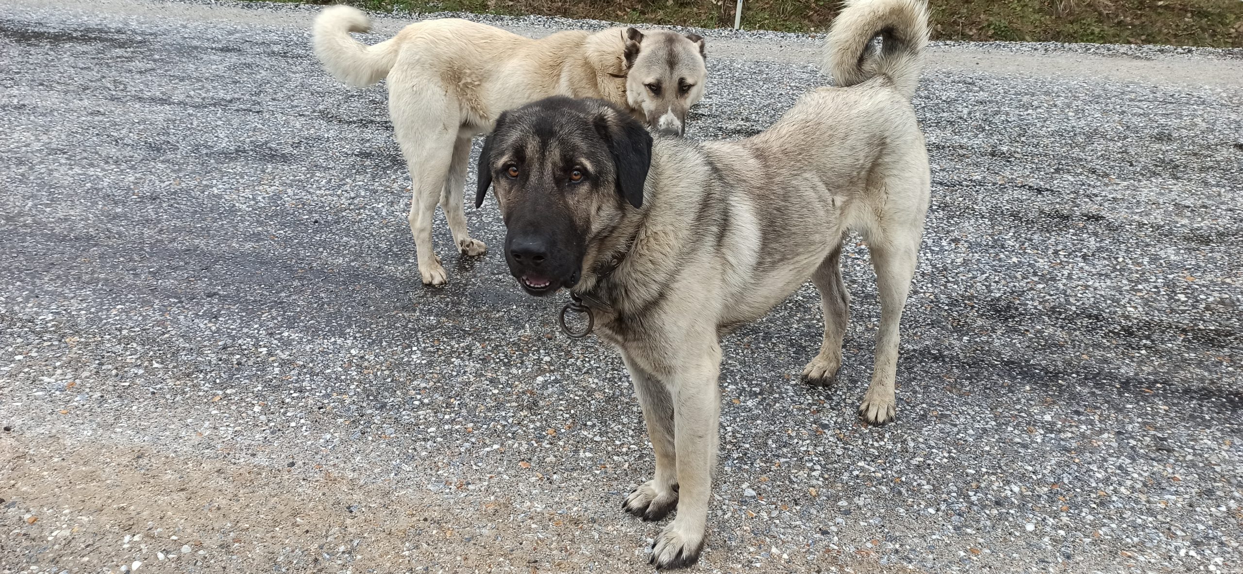
Karabaş and Akbaş on the road together!
When I arrived in Hacıosman Village after Kutluca Village, other dogs welcomed me. Luckily, they seemed calmer and more docile this time around. Two of them, both male, were very interested in me; one was large, its body was cream-colored, and its face and nose were pitch black; I called him Karabaş (Blackhead). The other dog was relatively smaller and still cream-colored, but had a white face and nose; Akbaş (White head) seemed right. They decided to walk with me. I immediately remembered the three days I spent with a dog named Diken on the Troy Cultural Route. As I continued, I wondered how far these fellow travelers would will walk with me this time.
Karabaş and Akbaş were two friends who got on well; they walked with me for about 8 km from Hacıosman Village to Gürmuzlü Village, playing games sometimes with each other and sometimes with me. There is a Sansarak Stream crossing about 3 km before coming to Gürmuzlu. In the guidebook of the Path of Tolerance, it is specifically stated that you can cross the stream only by removing your shoes. When you get there, you see that you have no other alternative so I crossed the stream as indicated. Meanwhile, Karabaş and Akbaş were watching me but they did not dare to enter the water and cross the stream, which was flowing quite fast with knee-deep water. When I started to walk again, I saw Karabaş entering the water and starting to cross. Then, taking courage from Karabaş, Akbaş entered the water. Karabaş completed the crossing and came to me. When I looked behind me one last time, I saw that Akbaş had come to the middle of the stream. Thinking that he had crossed the stream, I continued on my way. After driving for a while, I realized that Karabaş was following me behind me, but Akbaş was not around. I think Akbaş failed to cross the stream and returned. So I said goodbye to one of my dogs at Sansarak Creek.

Goodbye to Akbaş
When I arrived in Gürmuzlü Village with Karabaş, some workers, who were gathered around a picnic table in the village square, offered me tea. Of course, Karabaş immediately caught their attention. Karabaş had a collar. They decided to detain Karabaş, thinking that maybe he could have an owner in Hacıosman Village. They tied a rope to his collar and began to feed him bread. The hungry Karabaş forgot about me and started to eat the bread given to him. I said goodbye and left Gürmuzlu Village. At that moment, I understood once again that one of the best things that can happen to you on a solo walk is when a dog accompanies you, even for a short time.
It was 15:30 when I set off from Gürmuzlü Village and arrived at Ömerli Village. I got there much earlier than I expected. Again, no one was in sight. The rain had intensified. When I looked around, I couldn’t find a place to set up a tent. For the next day, worse weather was expected. If I could reach Iznik by evening, I could at least spend the night in a hostel or hotel. On Friday, I could return to Istanbul in time. With these thoughts in mind, I decided at that moment to continue the walk.
After Ömerli Village, the route descends with the magnificent view of İznik Lake and then passes through olive groves and orchards to reach İznik. Before you reach Iznik on the route, you see the Obelisk, the monumental cypress tree, the Merdivenli Rock ceremony place, the monumental plane tree and the underground burial chamber.
When I arrived in Iznik after seeing all these sights, my odometer was showing 34.5 km. This distance has been recorded as the longest distance I have walked with a full rucksack. Of course, everything had a price. My feet had reached the end of their tolerance. When I collapsed on the ground in front of the Murat I Bath, which was the end point of the walk, I could no longer take a single step. After barely walking the last few hundred meters, I managed to throw myself into a hotel. Thus, I finished another route with my aching feet and good memories in my mind.
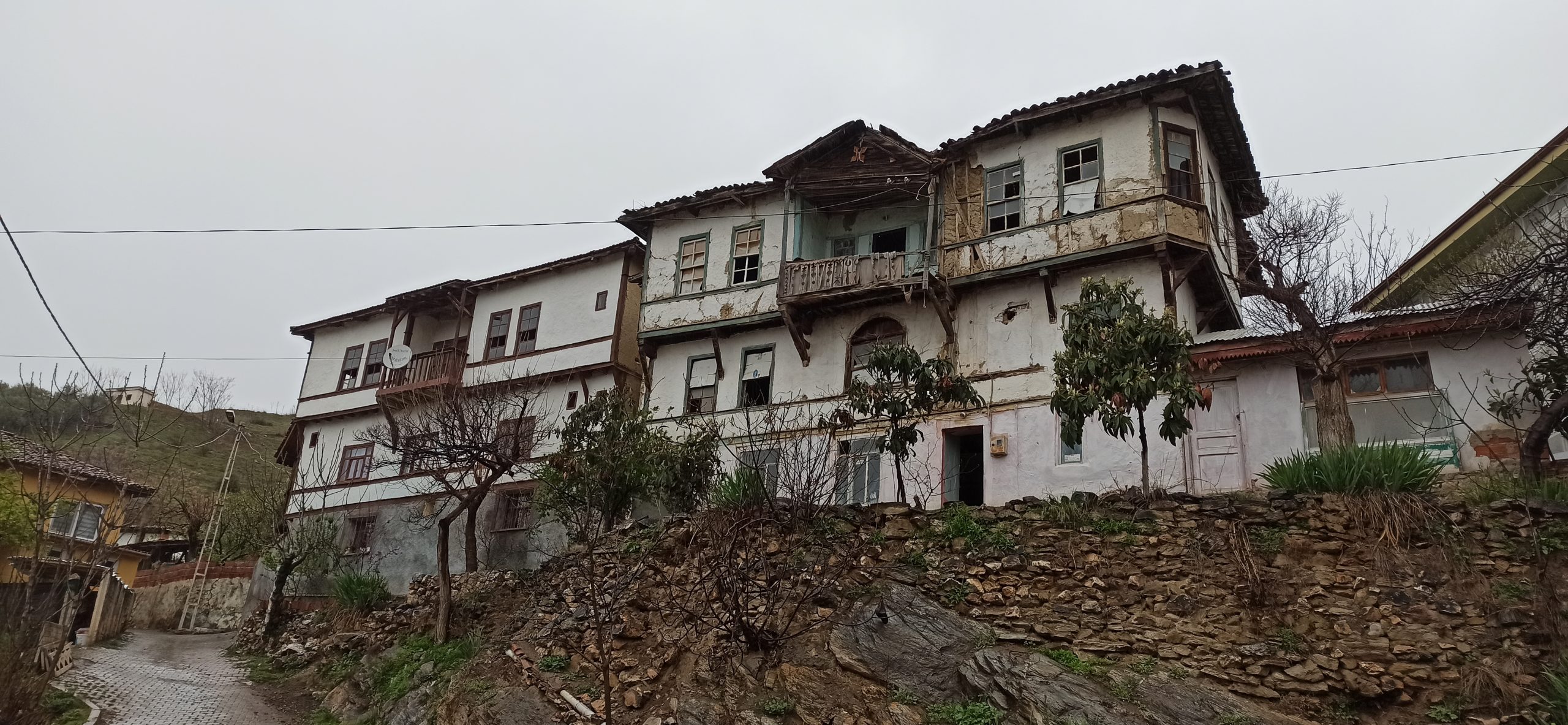
Old house on the descent to İznik
The Tolerance Way is a beautiful path that anyone with a little hiking experience can easily walk on in spring, autumn and even summer. On the Tolerance Way, you will not have any difficulties in terms of water supply, but there are not many points for food supply, as the route is relatively new. Therefore, at the moment, those who want to walk on the route should carry their food with them. In addition to having many advantages such as being both close to the cities and so far away, including unique forest and mountain views, passing through a wetland, another important feature of the Tolerance Way is that it starts from the city of Canterbury in England and ends in Demre in Antalya. For it is a part of the Via Eurasia Cultural Route that passes through the district. In other words, when you walk on the Tolerance Way, you also walk a part of the Via Eurasia. With such an opportunity, I recommend that you add the Tolerance Way to your walking agenda as soon as possible.
Hoping to meet you on other routes, your path is clear and your red and white signs are always visible…
Oytun Güventürk
April 2021
https://www.instagram.com/tonyukukoytun/
https://www.wikiloc.com/wikiloc/user.do?id=2443661


1 Comment
ebdaa
May 21, 2023
That’s totally right. اصلاح مسابح بالرياض
Write a comment: